The Fitz Roy: An icon of Patagonia
the Fitz Roy Mount is a famous mountain in El Chalten, Patagonia, Argentina. It´s very recognized due to the amazing trekkings you can enjoy in the area, from the small village of El Chalten
El Chalten
El Chaltèn is the gate to enjoy different trekkings in the area of Fitz Roy Massif.
And the king there is the Fitz Roy Mount. A mountain in Patagonia, on the border between
Argentina and Chile. It is located in the Southern Patagonian Ice Field, near El Chaltén
village and Viedma lake. It was first climbed in 1952 by French alpinists Lionel Terray
and Guido Magnone. A bit of history about this incredible mountain. Now, what you can do
here? Many options are available. But what`s important is to choose the most suitable one for
you. Take a look at the different trekkings in the area of Fitz Roy Mount
Fitz Roy Mount: Basic facts
Monte Fitz Roy (also known as Cerro Chaltén, Cerro Fitz Roy, or simply Mount Fitz Roy) is a mountain in Patagonia, on the border between Argentina and Chile. It is located in the Southern Patagonian Ice Field, near El Chaltén village and Viedma lake in Argentina. It was first climbed in 1952 by French alpinists Lionel Terray and Guido Magnone.
The original inhabitants, called the mountain as Chalten. In fact, they referred to this mountain as “Chaltel” or “Chaltén” that means “smoking mountain”, a name no doubt inspired by the clouds that so often trail from the summit. It was Francisco Pascasio “Perito” Moreno that renamed the peak after Robert Fitz Roy, an English astronomer and sailor (1805-1865), who was partly responsible for the first accurate mapping of the intricate watersheds and shorelines of Patagonia and Tierra del Fuego. On his second trip to Patagonia in 1834, together with Charles Darwin, Fitz Roy set out to explore the Río Santa Cruz in hopes of reaching the Andes, but after sailing 140 miles upriver they were forced to turn around, resigning themselves to a very distant sight of the snow-covered mountains
Now, from El Chalten, you can start many options of trekkings to this incredible massif. Take a look to some of the most important circuits you can enjoy once there:

Fitz Roy and El Chalten: Where is located?
El Chalten is located 213.5 km from El Calafate, so you have to arrive to El Calafate airport first and then take any of the bus services between both cities, or take a private transfer. You also can rent a car. Check our map
Fitz Roy: Location Map

Fitz Roy Mount: Trekking trails in to the Fitz Roy
Fitz Roy: Easy trekkings
Up to 2 hours of trekking activity in Fitz Roy Massif
First: If you are not used to walking in the mountains or if you doubt your physical condition it is highly recommended that you start doing short walks before undertaking hikes of longer length
Fitz Roy: Trekking to Cascada Margarita
2 hours, easy difficulty
From El Chaltén in the way to Laguna Torre footpath and after a small climb enter
a small forest composed mainly of Ñires Trail. In a few minutes you will be under
the protection of the forest, on a very comfortable trail with a very gentle slope.
The path starts to gain height and straighten up alongside the course of the
Fitz Roy river until you arrive at a natural viewpoint elevated on a cliff edge
over the river. The panorama from this viewpoint presents to the west the valley
of the Fitz Roy river and its serpentine course in the background, framed by the unique
Mount Solo on the left, the backdrop of the Adela range and the impressive Mount Torre,
and on the right you can see the Mount Fitz Roy. Just across the river canyon you can see the
Margarita waterfall. If you have additional time, it is worth continuing on the trail for an
hour more until arriving at Mount Torre viewpoint, one of the two most spectacular
lookouts in the area.
Fitz Roy: Trekking to Los Condores and Las Aguilas
2 hours, easy difficulty
Starting from El Chaltén, you cross over the access bridge of the Fitz Roy river and then continue along
to the trailhead starting at the National Park Visitors’ Centre. After a short walk you cross a small gate
with a sign indicating the way to the left, and a few steps further you will see a second sign showing you
the trail plan. From here it will be another half hour until you reach the Los Cóndores viewpoint.
This footpath is relatively new, since it has been opened in 2004. It is well signposted and on its way
you will find several informative signs that will let you appreciate the landscape around you.
As its name indicates, the viewpoint is strategically located for the eventual observation of condors in their frequent flight between the valleys of the De Las Vueltas river and the Fitz Roy river. Furthermore, it is an excellent alternative for admiring the impressive granite peaks and glaciers dominating the horizon. Contemplating the sunset from this viewpoint can be a great farewell from El Chaltén. The trail to the Las Águilas viewpoint begins at the signposted bifurcation about ten minutes before arriving at the Los Cóndores viewpoint. This short trail has a gentle slope and as you go along you will discover the great Viedma lake on the horizon. The viewpoint is a natural balcony with a panoramic view over the steppe and the Viedma lake to the south, the Cerro Huemul to the west and the Cerro Piramide to the east.
Fitz Roy: Chorrillo del Salto
2 hours, easy difficulty
This pleasant trek is perfect for first contact with the natural environment of El Chaltén, you walk through a forest area in a footpath with no difficulty. At the end of the trail, a lovely waterfall and its stream invite you to take a break for contemplation at the shelter of the native forest. The trail begins in El Chaltén, at the end of Av. San Martín, on the same trailhead towards Laguna De Los Tres; You must take the path going to the right. In a short time, the trail ascends, and immediately after it descends until you reach the unpaved route that leads to the Lago del Desierto (Provincial Route 41). Shortly after you will find a signpost on your right-hand side indicating the entrance to the “Bicisenda”(bike trail) -a path exclusively for cycling, do not enter- and after a few minutes more, you will see another signpost to your left indicating that the path to the Chorrillo del Salto continues crossing the low forest of Ñires entering the foothill area again.
In the last section of the trail, you enter only on foot, it is forbidden to enter with bicycles. This beautiful footpath is completely flat, between low trees. The distant sound of the waterfall anticipates that you are approaching the end of the route. At the side of the trees you will find, according to the season, different flowers of the local vegetation, such as the beautiful Magellanic orchid. The waterfall is on the last leg of the Arroyo del Salto before it flows into the De las Vueltas river. The total distance of this trek is less than 4 km from El Chaltén.
See our Fitz Roy Trekking Trails Map

Fitz Roy: Easy to moderated trekkings
Up to 5 hours of trekking activity in Fitz Roy Massif
Fitz Roy: Cerro Torre Viewpoint (Mirador del Cerro Torre)
4 hours, easy to moderated difficulty
This viewpoint is halfway towards Laguna Torre. There are two trailheads starting from El Chaltén which merge within 5 minutes walk. In a small Ñire wood you will find a signpost with a plan of the route with times, distances, and recommendations for you to take into account before continuing. The trail begins entering the valley with a gentle ascend in the shade of the first Lengas, and very soon straighten up alongside the Fitz Roy river canyon where the Margarita viewpoint is located. From here you have a panoramic view of Mount Solo, the Adela range, Mount Torre, and Mount Chaltén, and on the other side of the river, you will see the Margarita waterfall.
The footpath continues through the native forest, following the course of the Fitz Roy River. After an hour and a half walking you will arrive at the Mount Torre viewpoint, you will find a signpost of the National Park describing the incomparable view in front of you: the magnificent view of the Adela range, the Mount Torre and the granite needles around.
Fitz Roy: Trekking to Capri Lagoon (Laguna Capri)
5 hours, easy to moderated difficulty
The trail begins at the end of San Martin Avenue, where the urban area of El Chaltén ends and the car park and the National Parks dome are located. During the first hour of trekking the slope is fairly steep until you reach the natural viewpoint of the De las Vueltas river valley. After a few minutes, you enter the Del Salto stream valley towards Mount Fitz Roy. As the Ñires begin to be more and more numerous around the trail and about an hour and a half later, you will find a signposted bifurcation that indicates the footpath to Laguna Capri (to the left) and towards the viewpoint of Mount Fitz Roy and Laguna de los Tres (to the right). From the lagoon, you will have a unique view of the Fitz Roy massif and its surrounded needles, a place that invites you to stay; one of the classic postcards of El Chaltén. If you have an additional 30 to 40 minutes, you can not miss the Mirador del Fitz Roy, a well-signposted natural rocky viewpoint, with a sign that allows you to interpret the mountains and the glacial landscape which appears before your eyes.
Fitz Roy: Moderated trekkings
Full day trekking activity in Fitz Roy Massif
Fitz Roy: Trekking to Torre Lagoon (Laguna Torre)
8 hours, moderated difficulty
From El Chaltén there are two head trails to Laguna Torre ; both paths merge within 5 minutes walk. The trail enters the valley of the Fitz Roy river and follows up alongside the stream to its source. At only 15 minutes walk you will access the first viewpoint located at the gorge of the Fitz Roy river which offers an impressive panoramic view of the Cerro Solo, Adela range, Cerro Torre and Mount Fitz Roy. Across the river canyon lies the Margarita waterfall. Halfway through the path you will reach a natural viewpoint with magnificent panoramic views of the Adela range, Cerro Torre and the satellite granite needles. Finally the trail crosses the De Agostini base camp where it is possible to spend the night in your tent. Leaving behind the campground, the path continues towards the frontal moraine, which ascends until reaching its crest after walking for 15 minutes. From there it is possible to go down to the Torre lagoon, or to continue along the same ridge for another 2 km to the Maestri viewpoint. This lagoon tends to group numerous icebergs on its shore which has fallen off from the front face of the Grande glacier. The mountains are always seen from the West, so they are directly illuminated by the sun only in the morning. You will achieve the best photographs at sunrise, when the color of the granite walls become saturated for a few minutes and the sunlight reach them for the first time. This picture is reserved only for those who stay overnight in the De Agostini campground waiting for that magical moment with a camera ready for when the sun comes up.
Fitz Roy: Trekking to Laguna de los Tres
9 hours, moderated difficulty
The trail head begins at the end of Avenida San Martín, where the urban area of El Chaltén
ends and the car park is located. During the first hour of trekking the path ascends steeply
up to a natural viewpoint of the valley of the De las Vueltas river. The trail continues up
along the Del Salto stream entering the valley towards Mount Fitz Roy. As the ñires become
more numerous along the way, approximately an hour and a half later you will reach a well-marked
natural rocky viewpoint with a sign that allows you to interpret the whole unforgettable
landscape. The path follows always up along the Del Salto stream to the drainage area of Laguna
Madre e Hija. Four hours ahead from the starting point you will arrive at Poincenot Base Camp
(the most popular camp site in the National Park) and after crossing the Blanco River, you will
reach its base camp (for climbers only). From here the path ascends steeply for approximately
400 metres until arriving to Laguna de los Tres, which will require more than an hour of effort.
The trail finishes at the ridge of the old frontal moraine of the De los Tres Glacier (enormous
formation in the shape of an arch that currently contains the lagoon, formed by the action of the
advance and subsequent glacial retreat) with an extraordinary view of the lagoon and De los Tres
glacier. This is the closest view to the granite wall of Mount Fitz Roy and the surrounding peaks.
If you make the effort to arrive at sunrise, the prize will be double, since you will be able to witness
the extraordinary moment when the hills are dyed red with the first rays of the sun. Going down the
moraine, and skirting the lagoon to its natural draining point, you will find a path heading towards
another breathtaking viewpoint: the desolate Laguna Sucia and its hanging glaciers. Although access
to this viewpoint is possible all year round, from April to October it will vary depending on the
accumulation of snow on the trail, especially in its final stretch.
Fitz Roy: Trekking to Pliegue Tumbado
8 hours, moderated difficulty
The trail starts at the National Park Ceferino Fonzo Visitors` Centre, where a small fence indicates two
paths: to the left, the trail goes to Los Cóndores and Las Águilas viewpoints, and to the right towards
Pliegue Tumbado and Laguna Toro / Paso del Viento. This trail maintains an ascending slope of
approximately 1100 metres in total (3,610 miles), until reaching the viewpoint located at about 1500 metres
(4,920 feet) above sea level. Due to its height, the absence of trees and the total exposure to the wind, you
should go prepared with a windproof jacket and warm clothes since a small snowfall is not uncommon
even in the middle of summer.
Having walked for about an hour, the trail crosses a plain called “Pampa De las Carretas”, from where you
can appreciate the impressive Mount Huemul, the Viedma lake to the south and the whole imposing Andes
to the northwest where Mount Torre and Mount Chaltén stand out. The trail then enters a beautiful forest
until reaching an altitude of approximately 1000 metres above sea level, where the landscape changes
abruptly: the trees turn to bushes and scrubby vegetation, and among the many stones on the way it is
possible to find the remains of marine fossils which are bout 100 million years old. The last part of the
trail fades away but it is still marked with yellow sticks until you reach the top of the Pliegue Tumbado -which can be snowed and if this is the case it is not recommended to continue- with an extraordinary
panoramic view.
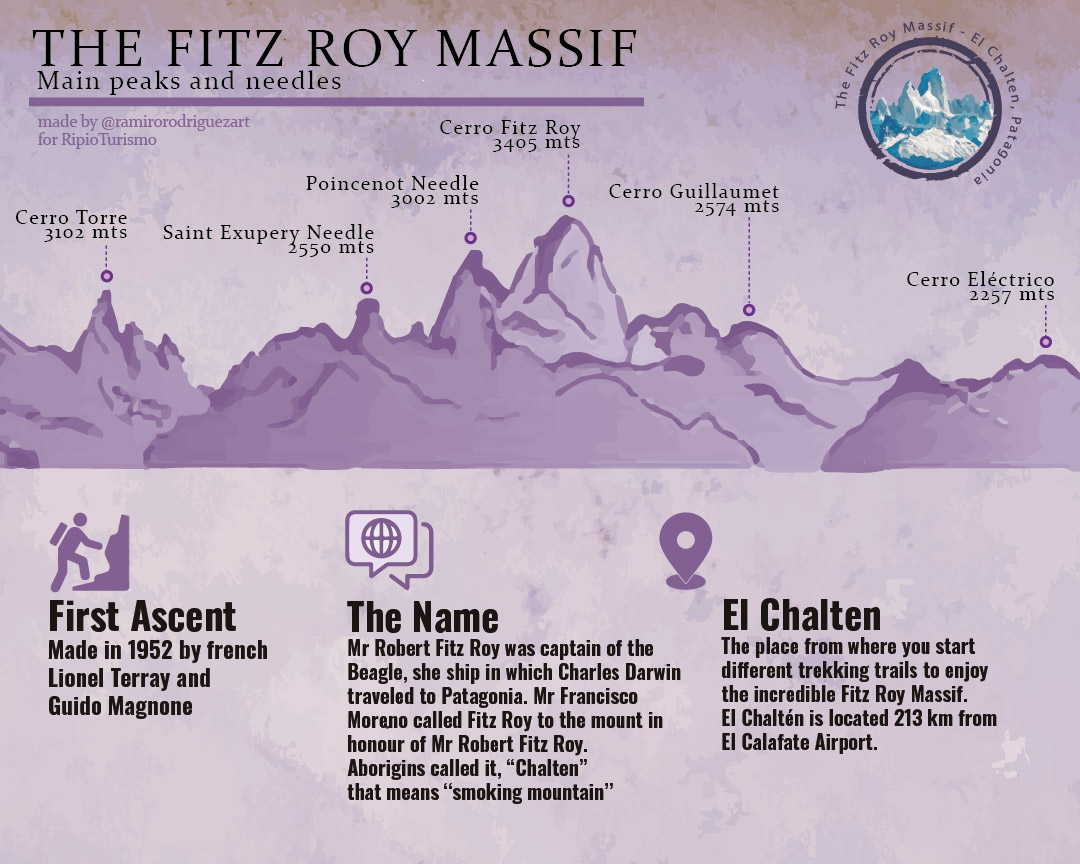
Fitz Roy: Main peaks and needles in the Fitz Roy Massif
The Fitz Roy Massif is a wonderful place to enjoy unique trekking trails and enjoy amazing landscapes. There are many different trails to choose from, and some of the most famous are the Trail to Cerro Torre, to Laguna de Los Tres, to Laguna Torre.
The local adventure specialists propose you to live different activities in this mountain paradise, in which you will reach corners impossible to know otherwise. According to your age, available time and physical condition, you can choose from a visit to historical sites to an expedition to the Patagonian Continental Ice Field.
Take a look to the following graphic with some interesting information about Fitz Roy Massif, main peaks, and needles:
Tour to El Chalten and Fitz Roy
Check an interesting tour including El Chalten and other great places in Patagonia:

Looking for something more intense? Check what following 3-day expedition to Marconi Pass in the Southern Ice Field

For more information, you can contact us at info@ripioturismo.com
Thank you!