Trekking in Ushuaia
Ushuaia is a wonderful place, of course the southermost city in the world, but also a great place to enjoy trekking activities. Check some great options you can choose during your trip to Ushuaia:
Trekking in Ushuaia: Trekking to Laguna Esmeralda
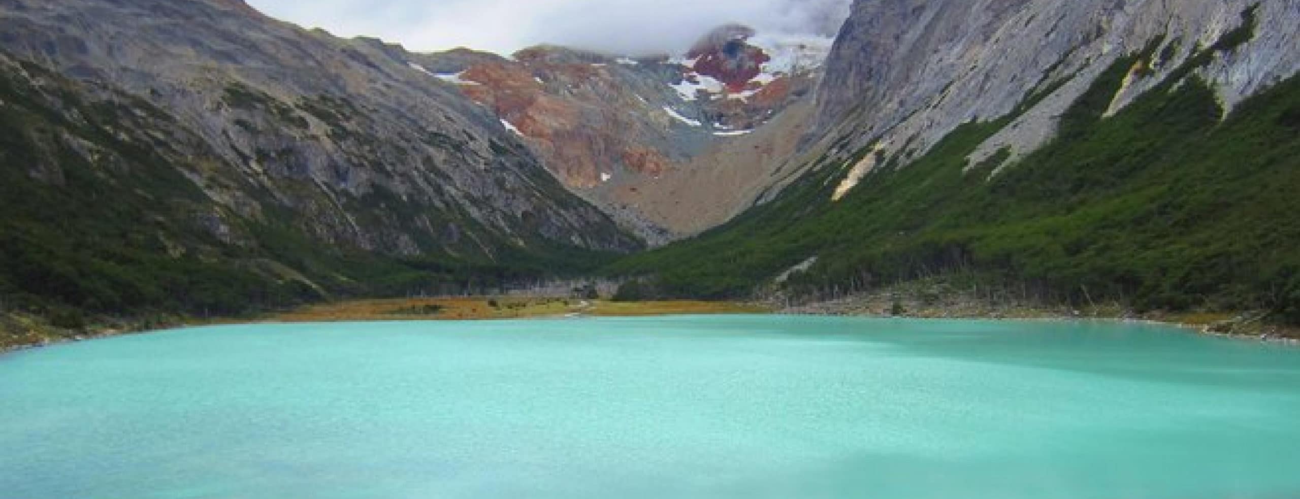
Te Laguna Esmeralda is an amazing place, located in Ushuaia, Tierra del Fuego. Ushuaia is the so-called “city at the end of the world”, and it is in a region that offers unforgettable images. This city located in a majestic passage stars in an untamed land by nature, a territory with a cold climate where you can experience the four seasons in the day. The Esmeralda Lagoon is an incredible place, whose color lives up to its name. The forests, mountains and glacier that surround it make it a place worth visiting. It is one of the “must see” or unmissable places in Tierra del Fuego, but yes, you have to like hiking and be willing to walk for about two hours, with a little cold depending on the season and walking through the peatlands.
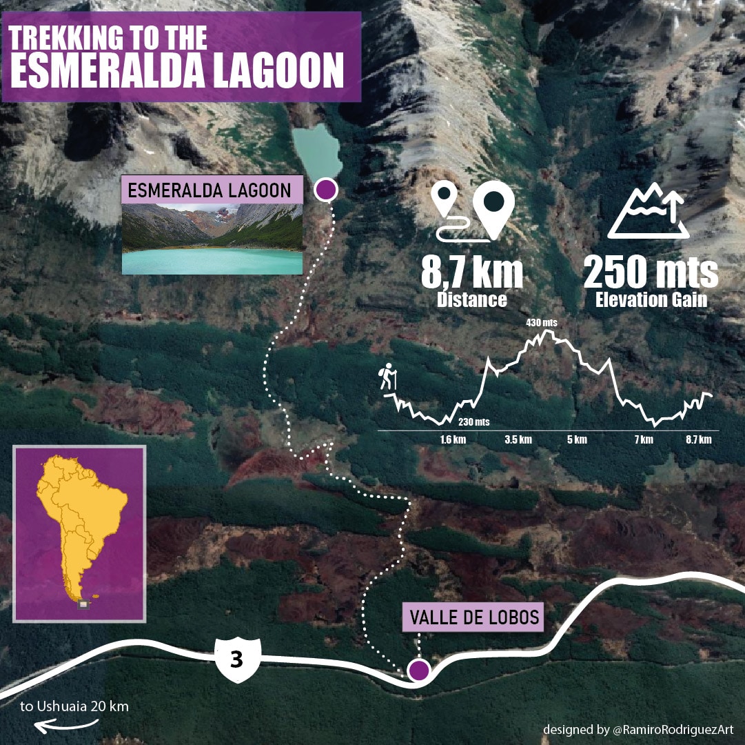
The Esmeralda Lagoon is located in the Tierra Mayor Valley, next to the Bonete hill in the Sierra Alvear, just 20 km from Ushuaia on Route 3. To get to the lagoon we must go along route 3 heading north until about 100 meters before the entrance to the Valle de Lobos. Between 18 and 20 km from Ushuaia. Just before the entrance to the Valle de Lobos you will see a clearing where you can leave your car, and if you search well, almost on the route you will find a small sign that says “Lag Esmeralda” indicating the path to follow.
It is necessary to wear comfortable shoes and clothes. If you wear trekking shoes better. Also bring water or a bottle to carry water in the streams, and something to eat, since you will have two hours going and another two hours back, plus the time you spend in the lagoon.
The trail begins inside the forest where you will find mud, depending on how much it has rained the previous days. But the path is easy and well marked. After leaving the forest, you will cross a peat bog where you will cross a wooden bridge, more specifically made of logs, over the Esmeralda stream. From where we can already see part of the havoc that beavers do in the forests of Tierra del Fuego and some of its dams, which are fascinating, a great work of engineering for these animals. Beavers are not native to Tierra del Fuego, so they cause serious damage to the local ecosystem.
Book Esmeralda Lagoon Trekking Activity
If you want to book the trekking to the Esmeralda Lagoon, click on the image below!
Laguna Esmeralda Trekking: General facts
Duration: 5 hours aproximately
Distance: 8.7 km
Elevation Gain: 250 mts
Dificulty level: medium
Turquoise colored lakes and lagoons have that color because they are fed by rivers that are born from large glaciers that are pushing through rocky valleys upstream, which have great power and crush the rocks into a fine-grained powder of silt and clay that with the river water generate the so-called “glacial milk”. The particles are slow to sink to the bottom, remaining suspended in the water column.
When sunlight hits water, these particles absorb the shortest wavelengths: purples and indigos. Meanwhile, the water absorbs the longest wavelength reds, oranges and yellows. That leaves mostly blues and greens to scatter back to our eyes.
Throughout the year there is a very important influx of walkers, therefore it is important not to access with pets or music, and to avoid any that could generate disturbances.
Trekking to the edge of the Martial Glacier Mountain
Another great option is the trekking to the edge of the Martial Glacier Mountain, a wonderful place located 7 km from the center of the city of Ushuaia, just 5 minutes from downtown Ushuaia passing through the Hotel Reserve of the same name.
Once you access the base, you must walk along the main ski slope or the variant through the forest, which follows the Buena Esperanza stream. Both roads begin at the base of the Mountain Center (level 315) ending at the panoramic point of the upper platform (level 515). The distance along the ski slope to the platform is approximately 1,300 meters, climbing a slope in the total of its route of 200 meters, the estimated time of ascent is 40 minutes (one way). While for the variant, the distance is approximately 1,500 meters, the same unevenness being the one that is climbed in its total route (200 meters), in an approximate time of 50 minutes. When you reach a viewpoint from which you have a panoramic view of the glacier and an interpretive poster of the surroundings, it is possible to choose between three different trails, the Filo is the one that is in an easterly direction, continuing along a quarry with practically no slopes. you get to a very wide view of the city and the Beagle Channel.
Main attractions: Lenga forest, transitional forest, high pasture, Andean desert, panoramic view of the Martial circus glacier, the city, the Beagle Channel, the Hoste and Navarino Islands.
Edge of the Martial Glacier Mountain Trekking: General facts
Duration: 3 hours aproximately
Distance: 5 km
Elevation Gain: 200 mts
Dificulty level: medium
Trekking to he Martial Glacier Viewpoint
The Martial Glacier Mountain Center is temporarily closed but its trails are publicly accessible. It is located 7 kilometers northwest of the city, just 5 minutes from downtown Ushuaia passing through the Hotel Reserve of the same name.
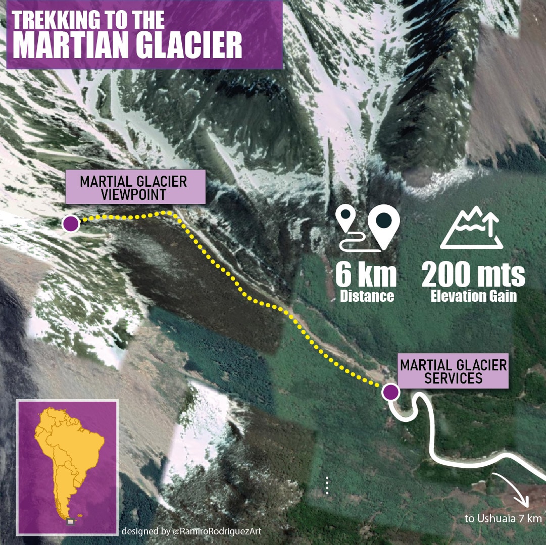
Once you access the base, you must walk along the main ski slope or the variant through the forest, which follows the Buena Esperanza stream. Both roads begin at the base of the Mountain Center (level 315) ending at the panoramic point of the upper platform (level 515). The distance along the ski slope to the platform is approximately 1,300 meters, climbing a slope in the total of its route of 200 meters, the estimated time of ascent is 40 minutes (one way). While for the variant, the distance is approximately 1,500 meters, the same unevenness being the one that is climbed in its total route (200 meters), in an approximate time of 50 minutes. When you reach a viewpoint from which you have a panoramic view of the glacier and an interpretive poster of the surroundings, the main path to the Martial glacier begins, you can see the zigzags and stone walls that lead to the millenary ice. It is a high mountain stone sector with a distance of 1,600 meters. uphill until reaching 825 meters high.
Duration: 4 hours aproximately
Distance: 6 km
Elevation Gain: 200 mts
Dificulty level: high
Trekking to Vinciguerra Glacier
The trekking to Vinciguerra Glacier is a medium-level Mountain Trail, but that in late autumn, winter or spring can have a high difficulty due to the presence of ice / snow and mud on a slope and that you have to walk all year round with boots, waterproof clothing and a coat .
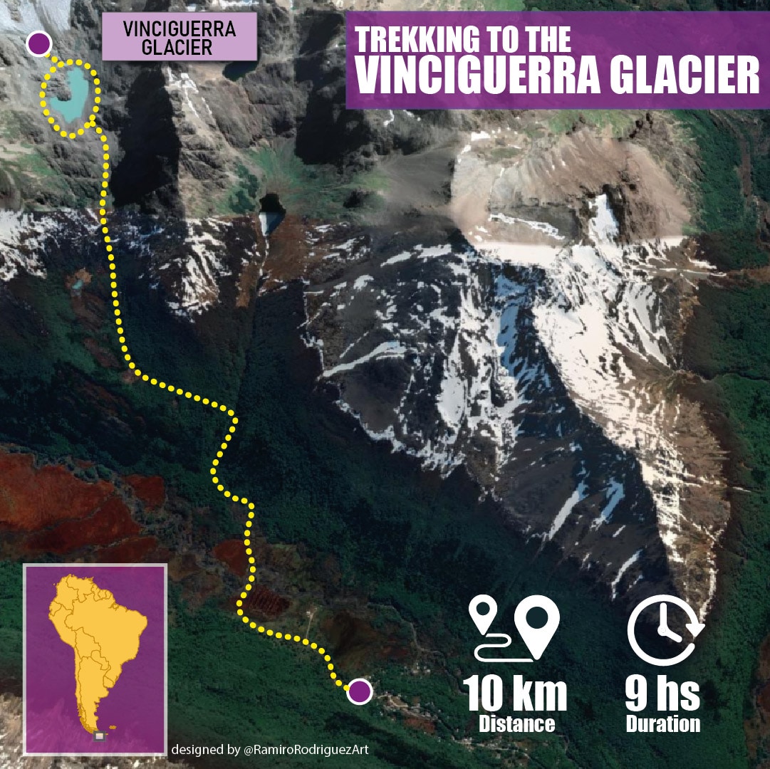
The tour begins at the bottom of the Valley of Andorra (gate). Then you cross a large peat bog and walk along the left bank of the Aº Grande. Once you cross a bridge you enter a forest area where the path is friendly, with some climbs that require more physical demand. When the vegetation limit is reached, a transition zone opens with a high-altitude wetland that gives way to the last ascent by a steep rock that will take us to the shore of the Laguna de los Témpanos.
At 1 km from the bridge is the fork to the Enchanted Lagoon. Measurement elements (stakes) are observed at the source of the water course and in the glacier mass that serve to monitor the behavior of Glaciers and their relationship with the phenomenon of Climate Change. Please do not touch them. The name Vinciguerra was given by the Italian expeditionary Giácomo Bove in memory of the zoologist who accompanied him on the Italian / Argentine scientific expedition to Tierra del Fuego in 1882.
Main attractions: Vinciguerra Glacier, Laguna de los Témpanos, Andorra Valley, Arroyo Grande.
Duration: 9 hours aproximately
Distance: 10 km
Dificulty level: medium
Trekking to Turquesa Lagoon and Carvajal Mount
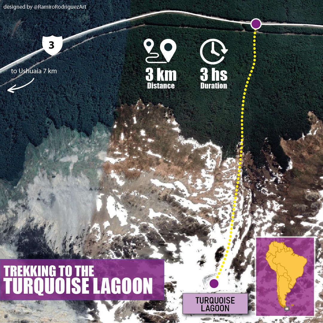
The turquoise lagoon is located in the Sierra Sorondo and its access is very close to the city of Ushuaia. The trail runs through an old loggerhead, therefore old cuts and marks are seen on the trees. Although it is signposted, with a well-marked path, we can classify it as a medium level of demand due to its maximum slope, making it difficult for hikers to access it in times of snowfall or rain. Outside the vegetation limit, it has views of the Sierra Alvear and the Esmeralda Lagoon.
Other information of interest: For a large part of the way you travel along the edge of the stream that rises in the Turquesa lagoon.
Main attractions: Sierra Sorondo, Sierra Alvear, Laguna Esmeralda, Laguna Turquesa, Olum Valley.
Duration: 3 hours aproximately
Distance: 3 km
Dificulty level: medium
Book the Trekking to Turquoise Lagoon and Carvajal Mount
If you want to book the Trekking to Turquoise Lagoon and Carvajal Mount, click here


